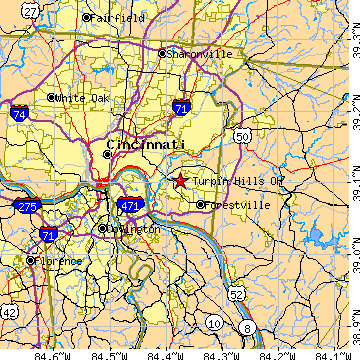
From the South:
- I-275 East / North (past Coney Island on East-end of Cinci)
- Left onto Five Mile Road (exit 69, going back under I-275)
- Follow Five Mile Rd until it ends (about 2.5 miles; thru about 6 lights)
- Left onto Clough Pike (follow it for about 1.5 to 2 miles; thru 3 lights)
- Right onto Turpin Hills Drive @ Flashing Yellow Light
From the North:
- 71-South (or 75-South)
- I-275 East / South towards Milford
- Route 28 West (exit 57, towards Milford / Cinci)
- After 1-2 miles, 28-W merges with Route 50-West
- continue winding thru charming downtown Milford;
- follow bridge over State & National Scenic Little Miami River
- 28-W ends; Stay on 50-W (becomes Wooster Pike)
- After 4-5 miles, Left @ Light @ Newtown Rd (becomes Church St after next Light)
- cross over Route 32; then, after about 1 winding mile,
- Right onto Stirrup Rd
- OR, continue for another 0.5 mile, going Right at fork in road to 1st STOP sign
- Right onto Clough Pike
- Right onto Turpin Hills Drive @ Flashing Yellow Light
Alternate from North (longer than above, but fewer turns):
- 71-South (or 75-South)
- I-275 East / South past Milford
- Route 32-West (exit 63; towards Newtown / Cinci; about 4.5 miles, thru Newtown)
- Left @ (~ 6th) Light onto Newtown Rd / Church St
- after about 1 winding mile, go
- Right onto Stirrup Rd
- OR, continue for another 0.5 mile, going Right at fork in road to 1st STOP sign
- Right onto Clough Pike
- Right onto Turpin Hills Drive @ Flashing Yellow Light
From Downtown:
- East on Columbia Parkway (US 50, for about 6.3 miles)
- past Delta & Stanley side streets and around the big bend near Ault Park
